Role profile: geospatial information specialist
Geospatial information specialists collect, collate, manage, and maintain geospatial data. They understand techniques for primary data collection used in surveying, geomatics, and remote sensing. They also understand methods for linking administrative data by geographic references.
Geospatial information specialists have experience working with a range of geospatial data sources. They understand the strengths and weaknesses of these data sources when they are applied to work in Government. They can represent and manage geographic information within spatial data infrastructures, applying relevant data standards and making informed assessments on data quality. They are able to use different geospatial technology platforms for managing geospatial data. They are also able to make them accessible to others, including building capability in their use.
Typical role responsibilities
Geospatial information specialists:
- capture and prepare geospatial data for use in business decisions – this includes processing the data by applying the relevant scientific knowledge, such as surveying, photogrammetry, geomatics, geocoding and addressing, cartography, and remote sensing
- generate derived, analysis-ready geospatial products through the design and application of processing workflow and corrections – an example of a product could be terrain and surface models from point clouds
- are responsible for managing and administering geospatial datasets from different sources – this involves working to governance and quality standards for geospatial information
- develop and follow geospatial strategies for maximising the value from geospatial investments – this involves ensuring the quality and security of resources is maintained
- administer geospatial data platforms and manage their datasets to provide efficient and accessible geospatial data services
- train other people to use geospatial data and related information systems
- contribute to the development and application of standards, policies and procedures for geospatial data
Skills
There are several important skills that geospatial information specialists need to be successful in their role.
Find out more about skill level definitions.
You must be able to demonstrate that you can understand and apply techniques to measure the physical and human world. You must also be able to abstract information about the world using geospatial models.
You will be expected to demonstrate these skills at different levels depending on the seniority of your role.
Associate geospatial information specialist
As an associate geographic adviser, you must have a ‘working’ skill level.
Geospatial information specialist
As a geographic adviser, you must have a ‘working’ skill level.
Senior geospatial information specialist
As a senior geographic adviser, you must have a ‘practitioner’ skill level.
Principal geospatial information specialist
As a principal geographic adviser, you must have an ‘expert’ skill level.
You must be able to geo-reference, correct, calibrate, project and transform geospatial data.
You will be expected to demonstrate these skills at different levels depending on the seniority of your role.
Associate geospatial information specialist
As an associate geographic adviser, you must have a ‘working’ skill level.
Geospatial information specialist
As a geographic adviser, you must have a ‘practitioner’ skill level.
Senior geospatial information specialist
As a senior geographic adviser, you must have an ‘expert’ skill level.
Principal geospatial information specialist
As a principal geographic adviser, you must have an ‘expert’ skill level.
You must be able to collate and manage datasets within a workflow and architecture for geospatial data. You must be able to demonstrate that you understand the legal and ethical issues around geospatial data including rights, liability, privacy, and access.
You will be expected to demonstrate these skills at different levels depending on the seniority of your role.
Associate geospatial information specialist
As an associate geographic adviser, you must have an ‘awareness’ skill level.
Geospatial information specialist
As a geographic adviser, you must have a ‘working’ skill level.
Senior geospatial information specialist
As a senior geographic adviser, you must have a ‘practitioner’ skill level.
Principal geospatial information specialist
As a principal geographic adviser, you must have a ‘practitioner’ skill level.
You must be able to demonstrate that you understand and can apply the standards and formats for geospatial data and technology interoperability. You must be able to understand different quality components of geospatial data, and the use of metadata.
You will be expected to demonstrate these skills at different levels depending on the seniority of your role.
Associate geospatial information specialist
As an associate geographic adviser, you must have an ‘awareness’ skill level.
Geospatial information specialist
As a geographic adviser, you must have a ‘working’ skill level.
Senior geospatial information specialist
As a senior geographic adviser, you must have a ‘practitioner’ skill level.
Principal geospatial information specialist
As a principal geographic adviser, you must have an ‘expert’ skill level.
You must be able to apply desktop and online tools for managing, analysing and displaying geospatial data. This could be interactively or in workflows.
You will be expected to demonstrate these skills at different levels depending on the seniority of your role.
Associate geospatial information specialist
As an associate geographic adviser, you must have an ‘awareness’ skill level.
Geospatial information specialist
As a geographic adviser, you must have a ‘working’ skill level.
Senior geospatial information specialist
As a senior geographic adviser, you must have a ‘working’ skill level.
Principal geospatial information specialist
As a principal geographic adviser, you must have a ‘practitioner’ skill level.
You must be able to support and train other people to use geospatial data in their work.
You will be expected to demonstrate these skills at different levels depending on the seniority of your role.
Associate geospatial information specialist
As an associate geographic adviser, you must have a ‘working’ skill level.
Geospatial information specialist
As a geographic adviser, you must have a ‘practitioner’ skill level.
Senior geospatial information specialist
As a senior geographic adviser, you must have an ‘expert’ skill level.
Principal geospatial information specialist
As a principal geographic adviser, you must have an ‘expert’ skill level.
You must be able to gather user requirements for geospatial data and apply them to the design of platform architectures or policies for governance.
You will be expected to demonstrate these skills at different levels depending on the seniority of your role.
Associate geospatial information specialist
As an associate geographic adviser, you must have an ‘awareness’ skill level.
Geospatial information specialist
As a geographic adviser, you must have a ‘working’ skill level.
Senior geospatial information specialist
As a senior geographic adviser, you must have a ‘working’ skill level.
Principal geospatial information specialist
As a principal geographic adviser, you must have a ‘practitioner’ skill level.
Sample career path
The geospatial information specialist career path shows some of the common entry and exit points for the role. It also shows the typical skill levels needed.
You can enter a geospatial information specialist role from other analytical professions or other professions, such as the Digital Data and Technology (DDaT) profession. You can also exit the role to join these professions.
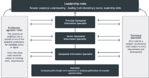
The diagram shows a potential career path. It shows that you can enter or leave a role from a wide range of backgrounds and experience levels. For example, you could become a geospatial information specialist by developing your skills in an associate role. You could continue to move up the levels in the career path by taking on more senior geospatial information specialist roles. Or you could develop your skills by working in a technical specialist role in an analytical or digital profession. You could also develop the necessary skills by working in a profession agnostic role outside of these professions.
A role that could be done by any person with the relevant skills or experience from any profession.
This could be a ‘badged’ or professional role that is subject to entry requirements and development.
Beyond the principal geospatial information specialist role, you could go into more senior leadership roles. These roles require broader analytical understanding, and the ability to lead multi-disciplinary teams.